Friday, December 10, 2010

Olympic National Park: Shaping Earth's Landscapes

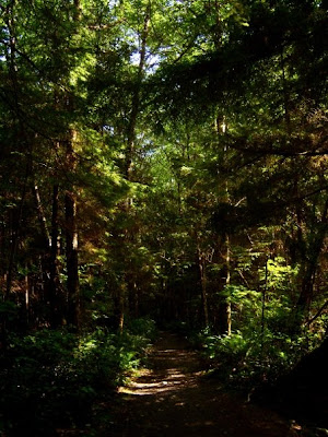
The main biome of Olympic National Park is a temperate rain forest biome. These rainforests in Olympic National Park include the Hoh Rain Forest and the Quinault Rain Forest, both named for rivers of the same name and the American Indian Tribes of the same name that have lived in the area for many years. The rain forest receives about 150 inches of precipitation annually. A temperate rain forest and tropical rain forest differ in that a tropical rain forest receives similar amounts of precipitaion all throughout the year while a temperate rain forest has more precipitation in the winter and less in the summer. A temperate rain forest also has more coniferous trees as opposed to tropical trees, and while there are many different species of plants and animals in a temperate rain forest, a tropical rain forest has much more.


(All three photos taken by myself on a hike in Olympic National Park)

Another major landscape in Olympic National Park are the Olympic Mountains, which contain many glaciers. There are a little over 250 glaciers on the Olympic Mountains. The movement of glacial ice on the mountains has created many different features such as lake basins, U-shaped valleys, jagged peaks, and cirques (http://www.olympic.national-park.com/). The most popular glaciers in Olympic National Park are the Blue Glacier and the Anderson Glacier.

Sources:
Class notes
Uhler, John William. Olympic National Park. Web. 8 Dec 2010. <http://www.olympic.national-park.com/>.

Olympic National Park: Earth's Place and Function


(A map of Olympic National Park, map: http://www.olympic.national-park.com/map.htm)

In order to gain some perspective on the relationship of Olympic National Park to the rest of the earth, I wanted to compare how much space the park takes up to the space on the surface of the earth. According to class notes, the diameter of the earth is about 8,000 miles, which would make the radius approximately 4,000 miles. To find the surface area of the earth, I used the formula Surface Area = 4π times r squared. I came up with a little less than 200,000,000 square miles.

The majority of that surface area is made up of water, and only about 29 percent of the earth's total surface area is land (http://www.physicalgeography.net/fundamentals/8o.html). Around 1,400 miles of land surface area makes up Olympic National Park.


(An aerial image of Olympic National Park saved from the Google Earth application on my computer)

(An aerial image of Olympic National Park saved from the Google Earth application on my computer)

The Google Earth application places Olympic National Park at approximately 47 degrees, 47 minutes, and 39.91 seconds North, and 123 degrees, 41 minutes, and 05.74 seconds West.

Olympic National Park is located in the state of Washington in the United States of America and is therefore in the Pacific Time Zone, making the time there an hour behind those of us in Colorado.

The marine climate of Olympic National Park causes the weather to be a little unpredictable, but the park typically is warm in the summers and mild in the winters. Winter is a wet season for the park, but the temperature of the area rarely drops below freezing. Summer is usually more dry than the rest of the year.

Sources:
Google Earth
Class Notes
"Introduction to the Hydrosphere." PhysicalGeography.net. Web. 9 Dec 2010. <http://www.physicalgeography.net/fundamentals/8o.html>
Uhler, John William. Olympic National Park. Web. 8 Dec 2010. <http://www.olympic.national-park.com/>.

Olympic National Park: Building Earth's Landscapes

(Olympic Mountains, image: onlinephotolibrary.experiencewashington.com)

The majority of the Olympic Mountains are part of Olympic National Park. The mountains themselves are the result of the subduction of the Juan de Fuca Plate. The Olympic Mountains aren't very tall. The tallest is Mount Olympus at about 8,000 ft. The mountains are made up of mostly basaltic and oceanic sedimentary rock. According to www.olympic.national-park.com, the sedimentary rock is the result of sediments being washed from the land to the sea. The sediments then became shale and sandstone. The mountains also have many glaciers. Most of the glaciers on the mountains are fairly small, but the glaciers on Mount Olympus are larger. While there are a few volcanoes in the state of Washington, there are no volcanoes in Olympic National Park. There are no volcanoes on the Olympic Peninsula. The closest volcanoes to the park are Mount Rainier and Mount Saint Helens, which are both located just southeast of the peninsula. The forest and the coast of Olympic National Park are also very geographically interesting. A lot of debris is washed up on the coast from the Pacific Ocean. The temperate rain forests contain many different rock types, as well as record size trees and a variety of animal species.


Sources:
"Potentially Active Volcanoes in Washington." Dynamic Maps. National Atlas of the United States, Web. 9 Dec 2010. <http://www.nationalatlas.gov/dynamic/dyn_vol-wa.html>.
Uhler, John William. Olympic National Park. Web. 8 Dec 2010. <http://www.olympic.national-park.com/>.

Thursday, December 9, 2010

Olympic National Park: Climate Basics and Processes

(map: http://www.olympic.national-park.com/map.htm)

Olympic National Park is located on the Olympic Peninsula in the state of Washington. What makes Olympic National Park so beautiful and interesting to visit is the fact that it consists of part of the Pacific coast, the Olympic Mountains, and even some temperate rain forest, including the Hoh Rain Forest and the Quinault Rain Forest. In this area, the climate is wet and temperate, and annual precipitation is usually about 150 inches (http://www.olympic.national-park.com/), due to the fact that it is right next to the Pacific Ocean. Most of the precipitation in the mountains is in the form of snow, but the rain forests encounter mostly rain. The temperate rain forest and Olympic Mountains are some of the wettest places in the United States. Directly to the east of the mountains, however, there is a rainshadow. The town of Sequim gets less than 20 inches of precipitation per year (http://www.olympic.national-park.com/).


(Average Annual Precipitation in Washington, map and legend: http://content.lib.washington.edu/cmpweb/resources/map-rainfall.html)

An interesting fact about the area near Olympic National Park:
The tiny town of Forks, Washington is the basis for the Twilight saga, by Stephenie Meyer. It is located on the Olympic Peninsula between the larger portion of the Park and the coastal region. So why did Meyer choose Forks as the setting for her teen vampire romance novel? The amount of rain and lack of sunlight. Vampire skin (according to Meyer) sparkles in the sunlight, so the vampire family, the Cullens, had to choose somewhere to live that had very few sunny days.


Sources:
The Pacific Northwest Olympic Peninsula Community Museum. Web. 8 Dec 2010. <http://content.lib.washington.edu/cmpweb/index.html>.
Uhler, John William. Olympic National Park. Web. 8 Dec 2010. <http://www.olympic.national-park.com/>.